
Storm News · Florida, July 2026
Tropical Storm Bertha Missed Florida. The Warning It Left Behind Didn't
The Short Answer
Tropical Storm Bertha, the second named storm of the 2026 Atlantic season, organized in the Gulf just off Florida's west coast over the weekend of July 18-19 and earned its name on Monday evening, July 20. It then tracked west toward Louisiana, leaving most of Florida with little more than heavy rain on the Panhandle, gusty winds, and dangerous rip currents along the Gulf beaches. That is good news, and it is also a warning. A storm went from open water to a named system in Florida's backyard in roughly a day, six weeks before the season's climatological peak, in a year many homeowners have mentally filed under "quiet season." If your roof took hail or wind on July 10-12, the window to get it inspected and documented is now, while the tropics are still giving you one.
In this article
What Bertha actually did, day by day
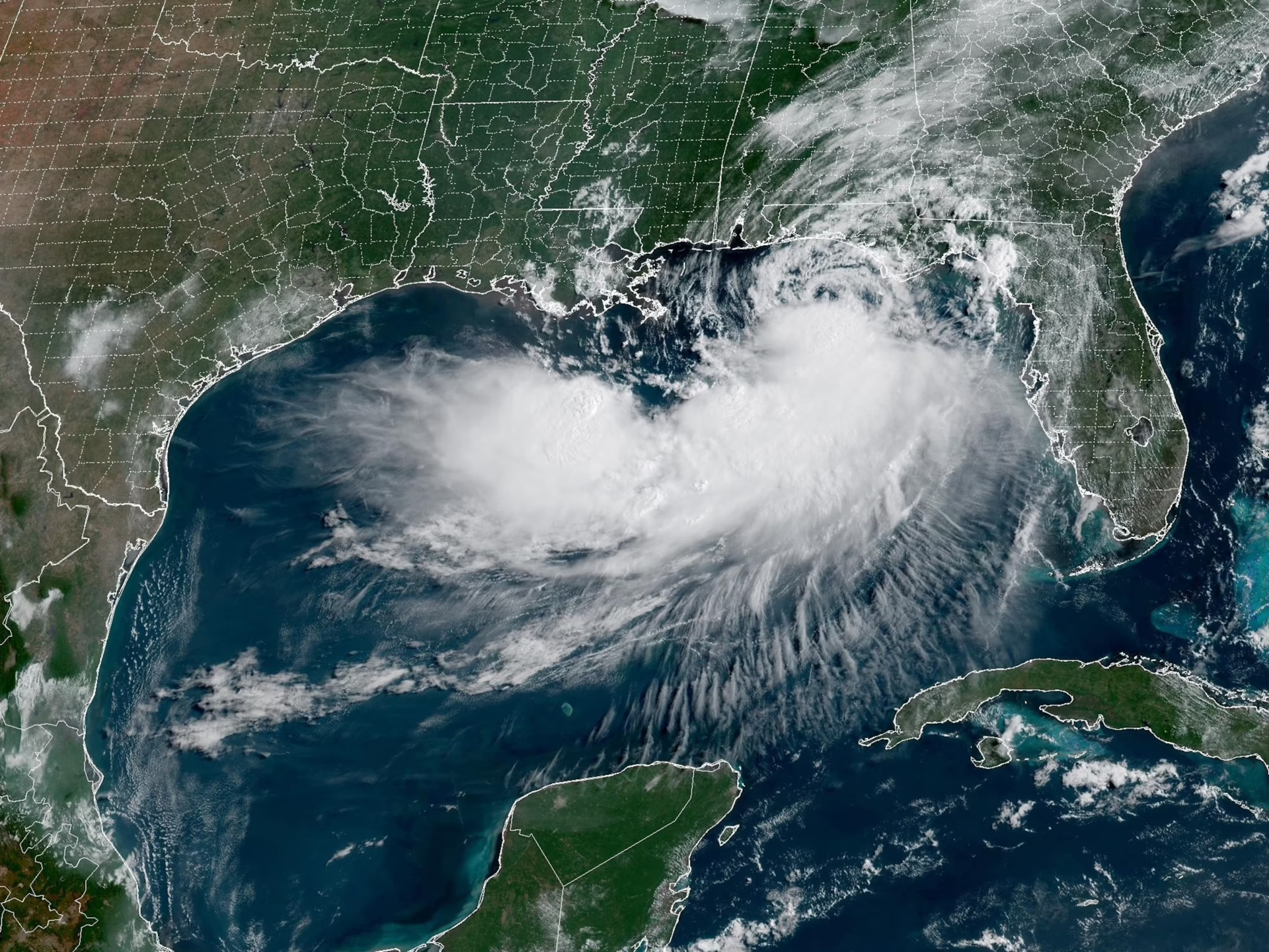
The system started as a tropical depression over the northeastern Gulf during the weekend of July 18-19, close enough to Florida's west coast that its outer rain bands were rotating across the Big Bend before it even had a name. By Monday evening, July 20, the National Hurricane Center upgraded it to Tropical Storm Bertha with sustained winds of 40 mph.
From there the story became a Louisiana and Texas story rather than a Florida one. By Tuesday, Bertha was sitting about 105 miles south-southeast of Mobile with winds up to 60 mph, crawling northwest at 6 mph, and a tropical storm warning was posted for New Orleans. Watches and warnings stretched from the Florida Panhandle, including Panama City and Pensacola, across to southeastern Louisiana. Forecasters flagged 2 to 4 inches of rain along the northern Gulf Coast with locally higher totals near 8 inches, storm surge of 1 to 4 feet, and life-threatening rip currents. As of this writing, Bertha has weakened to around 50 mph near the mouth of the Mississippi River and is expected to fizzle into a remnant low over southern Texas within a couple of days.
For JAEA's markets, Orlando, Tampa Bay, Jacksonville, and the Treasure Coast, the direct impact was minimal: rougher surf and rip currents on the Gulf side, scattered tropical downpours, and that was about it. Nobody in Brandon or Port St. Lucie is filing a Bertha claim this week. Which is exactly why this storm is worth writing about.
Why a miss still matters: the lead time problem
Bertha was what forecasters call a homegrown storm. It did not march across the Atlantic for a week the way Cape Verde hurricanes do, giving everyone days of track maps and cone updates to argue about. It bubbled up out of warm Gulf water a short distance offshore and had a name within roughly a day of getting organized.
That compressed timeline is the part homeowners should sit with. A Gulf system that forms that close to the coast leaves you a day or two of real preparation time, not a week. If Bertha's steering pattern had nudged it northeast instead of west, the first serious wind-driven rain would have arrived on the Nature Coast and Tampa Bay while most people were still deciding whether to take it seriously. There is nothing you can do about steering patterns. What you can control is whether your roof enters that day-or-two scramble already inspected, already repaired, and already documented, or whether you find out about a lifted shingle tab when it becomes a ceiling stain in the middle of a tropical downpour.
That is the entire argument of our hurricane season roof prep guide, and Bertha just handed Florida a live demonstration of why the timing in that guide is not padding.
The "below normal season" trap
Here is the mental shortcut we keep hearing from homeowners this summer: NOAA called for a quiet season, so the roof can wait a year. The first half of that sentence is accurate. NOAA's outlook for 2026 forecasts 8 to 14 named storms, with 3 to 6 becoming hurricanes and 1 to 3 reaching major hurricane strength, and gives the season a 55% chance of coming in below normal, largely because an El Nino pattern is expected to strengthen through the season and El Nino tends to suppress Atlantic storm formation.
NOAA 2026 Atlantic hurricane season outlook, issued May 2026. An average season produces 14 named storms and 7 hurricanes.
The second half of the sentence is where roofs get lost. NOAA itself repeats the same caveat every single year: the outlook is a count forecast, not a landfall forecast. It predicts how many storms will form somewhere in the Atlantic basin. It says nothing about whether one of them ends up over your zip code. Florida's most expensive lesson on this point is 1992, a season so quiet that its first named storm did not form until mid-August. That storm was Andrew.
Two more details from this year's setup deserve attention. Bertha is already the season's second named storm, and July is early. And last season, 2025, packed most of its activity into the stretch after September 10, the climatological peak, a reminder that a slow start tells you nothing about how a season finishes. Quiet-season years do not lower the stakes for your individual roof. They lower the number of chances. The one chance that shows up still hits at full strength.
What our crews are seeing on roofs right now
This is the part of the story we can speak to firsthand, because we have spent the last two weeks on roofs across all four of our markets following the severe weather of July 10-12. Verified storm-tracking data put roughly 25,000 Tampa Bay homes in a hail path on July 10, over 72,000 Jacksonville-area homes in a hail and wind swath on July 11, and more than 56,000 Treasure Coast homes in a wind zone on July 12. We broke down the full event, city by city, in our July 10-12 Florida storm damage roundup.
What our inspectors keep finding on those roofs is exactly the profile you would expect from small hail plus 50-65 mph gusts, and exactly the kind of damage a tropical system exploits. Granules collecting at downspout outlets on shingle roofs in Brandon and Valrico. Hairline-cracked tile on south and west-facing slopes around Port St. Lucie that looks completely intact from the driveway. Shingle tabs near ridge lines in Jacksonville that lifted in the wind, resealed in the heat, and now have a compromised bond you can only find by hand. None of it is leaking today. Most of it will not leak in a normal afternoon thunderstorm either.
A tropical storm is a different test. Wind-driven rain arrives sideways for hours, working at every weak seal and every cracked tile from angles ordinary rain never reaches. A roof that shrugged off July 10 can fail in October, and when it does, sorting out which storm caused what becomes a genuinely harder conversation with your insurance carrier. Getting damage inspected and photographed now, while it is clearly attributable to a documented July event, is how you keep that conversation simple. If the damage is already there, our storm damage repair team handles the fix and the documentation together.
Was your home in the July 10-12 storm path?
Free inspection with dated photo documentation across Orlando, Tampa, Jacksonville, and the Treasure Coast. No claim required, no pressure either way.
Schedule My Free InspectionYour window: now through late August
The Atlantic's climatological peak lands on September 10, and the heart of the season runs from roughly mid-August through October. Working backward from that calendar, the next four to five weeks are the practical window for anything that involves scheduling, materials, or an insurance carrier.
A free roof inspection is the floor. It costs you nothing, takes under an hour, and produces the dated photo record that protects you whether or not this season ever throws a storm your way. If your home is on the west coast of the state, a wind mitigation inspection in Tampa is worth stacking on top of it, since documented wind-resistant features are one of the few things that reliably reduce a Florida homeowner's insurance premium rather than just protecting the house.
And if your roof is 15-plus years old, was in one of the July swaths, and you already knew a replacement was coming, timing matters more than most people assume. A roof replacement in Tampa scheduled in early August goes on before the peak. The same project after a landfall joins a backlog of thousands, at whatever the post-storm market looks like. We watched that sequence play out after every major Florida landfall of the past decade. The homeowners who moved before the storm got their pick of schedule. Everyone else got a waiting list.
Bertha gave Florida a free rehearsal this week. The season will not always be that generous.
Frequently asked questions
Did Tropical Storm Bertha hit Florida?
Not directly. Bertha formed off Florida's west coast on July 20, 2026, then moved west along the northern Gulf toward Louisiana. Florida's impacts were limited to heavy rain and gusty winds near the Panhandle, tropical downpours in the Big Bend, and dangerous surf and rip currents along Gulf beaches. Central Florida, Tampa Bay, Jacksonville, and the Treasure Coast saw no significant direct impact.
Is the 2026 hurricane season really forecast to be quiet?
NOAA's outlook calls for 8 to 14 named storms with a 55% chance of a below-normal season, mainly due to a developing El Nino. NOAA also stresses every year that the outlook is not a landfall forecast. A below-normal season can still put a hurricane over Florida, and the 1992 season, which produced Hurricane Andrew, is the standard example of a quiet year with a catastrophic landfall.
Does El Nino mean Florida is safe this year?
No. El Nino tends to reduce the number of Atlantic storms that form, but it does not steer the ones that do form away from Florida, and Atlantic water temperatures in 2026 are still running slightly warmer than normal, which partially offsets El Nino's suppressing effect. Fewer storms means fewer chances of a hit, not a season without risk.
My roof was in the July 10-12 hail path but looks fine. Does Bertha change anything?
Bertha itself did not touch your roof, but it marks the point in the calendar where tropical activity has started. Hail and wind damage from July 10-12, like granule loss, hairline tile cracks, and lifted shingle tabs, is often invisible from the ground and holds up fine in ordinary rain, then fails under hours of wind-driven tropical rain. An inspection now documents the damage while it is clearly tied to the July event, which keeps any future insurance conversation much simpler.
When does hurricane season peak in Florida?
The Atlantic season runs June 1 through November 30, and its climatological peak is September 10. The most active stretch typically runs from mid-August through October, which is why late July and early August are the practical deadline for inspections, repairs, and any roof replacement you want finished before the peak.
What does a pre-season roof inspection from JAEA include?
A trained inspector checks the full roof system: shingle or tile condition, ridge lines and edges where wind uplift concentrates, flashing, penetrations, vents, and visible underlayment issues, plus gutters and soft metal for hail evidence. You get dated photo documentation of everything found, whether the answer is "you're fine," a small repair, or a claim-worthy problem. The inspection is free across all four JAEA offices.
One storm season. Four offices. Zero cost to know where you stand.
Orlando (407) 677-7663 · Tampa (727) 953-3181 · Jacksonville (904) 367-2913 · Port St. Lucie (772) 204-2452
Get My Free Inspection Before Peak Season