
Tropical Storm Isaias Florida Update: State of Emergency Declared as Hurricane Threat Grows
Isaias strengthened into a tropical storm early Wednesday in the Gulf and is forecast to become a hurricane as it moves toward the northern Gulf Coast. Florida has already declared a state of emergency in 25 counties while emergency teams stage resources ahead of possible wind, storm surge and flooding impacts.
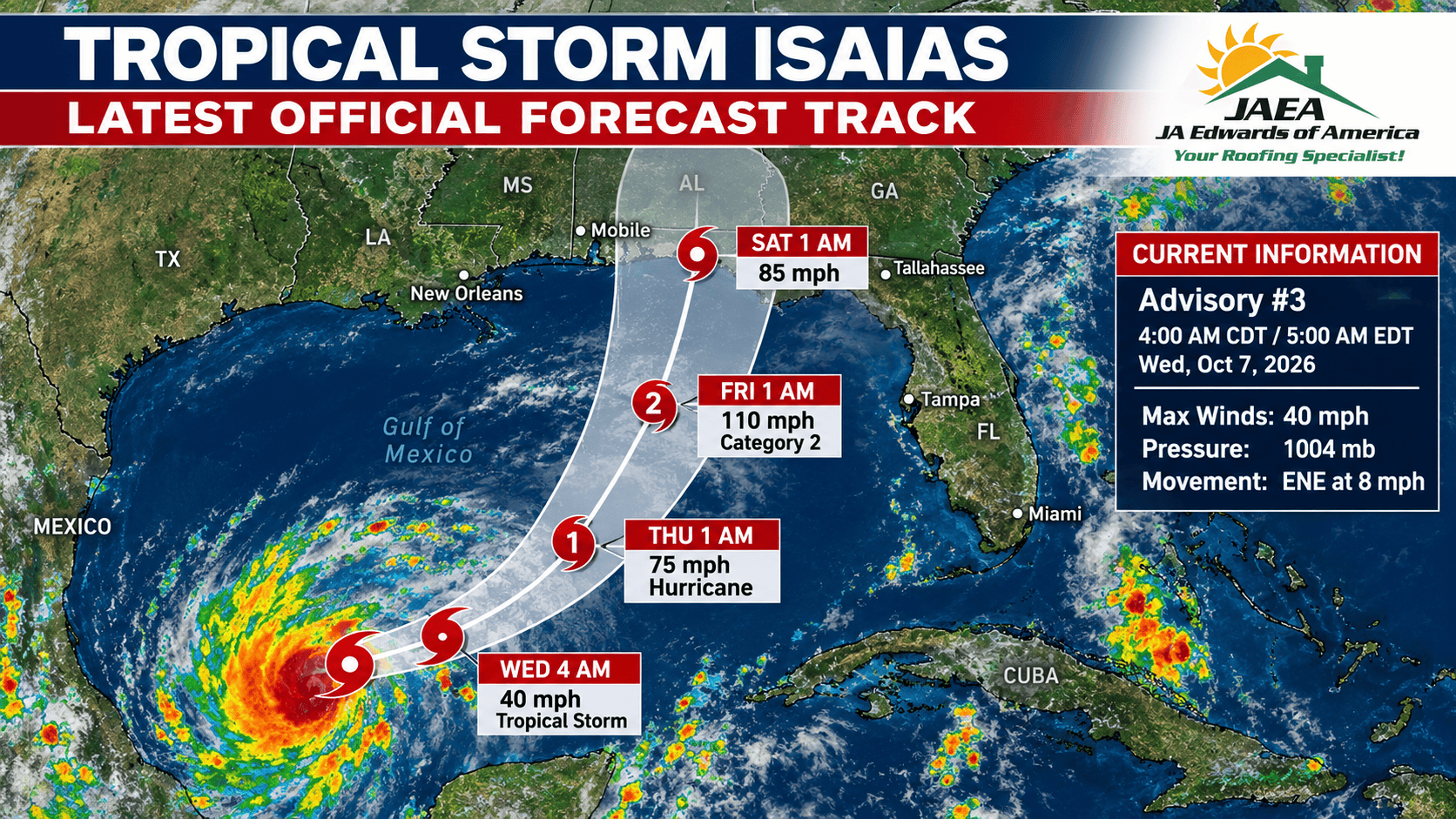
Florida is preparing for a potentially significant Gulf Coast storm late this week. Tropical Depression Nine strengthened into Tropical Storm Isaias early Wednesday, October 7, and the National Hurricane Center says rapid strengthening is possible over the next couple of days. The current forecast brings Isaias to hurricane strength on Thursday and near the northern Gulf Coast late Friday into early Saturday.
The most important word in that sentence is forecast. The exact landfall point is not locked in. As of Wednesday morning, the broader area of concern extends from eastern Louisiana to the western Florida Panhandle, and the NHC is warning residents across the northern Gulf Coast to keep checking new advisories as the track becomes clearer.
Where Is Tropical Storm Isaias Right Now?
At 4:00 AM CDT on Wednesday, October 7, the National Hurricane Center located the center of Tropical Storm Isaias near 22.0°N, 94.1°W, about 285 miles west of Progreso, Mexico, and roughly 580 miles southwest of the mouth of the Mississippi River.
Maximum sustained winds had increased to 40 mph, with the system moving east-northeast at about 8 mph. The NHC says the storm is moving through an environment that could support rapid strengthening, and its official forecast makes Isaias a hurricane by Thursday morning.
Hurricane and storm surge watches were not yet in effect at the time of the advisory used for this article, but the NHC said watches would likely be needed for part of the northern Gulf Coast later Wednesday.
Isaias Forecast Timeline: Wednesday Through Saturday
The NHC's Wednesday-morning intensity forecast shows a fast strengthening trend. That is what makes this system worth watching now instead of waiting until the day before landfall.
| Forecast Time | Forecast Wind | Expected Status |
|---|---|---|
| Wed. morning, Oct. 7 | 40 mph | Tropical Storm — observed at Advisory #3 |
| Wed. afternoon | About 60 mph | Strengthening Tropical Storm |
| Thu. morning, Oct. 8 | About 75 mph | Category 1 Hurricane forecast |
| Thu. afternoon | About 90 mph | Category 1 Hurricane forecast |
| Fri. morning, Oct. 9 | About 110 mph | Strong Category 2 Hurricane forecast |
| Fri. afternoon | About 105 mph | Category 2 Hurricane forecast |
| Early Sat., Oct. 10 | About 85 mph | Hurricane forecast near/inland along northern Gulf Coast |
Those numbers are not a guarantee that Isaias will reach exactly 110 mph, nor do they guarantee a specific landfall location. Intensity forecasting is one of the hardest parts of tropical meteorology, and forecasts can change quickly when a storm is moving over very warm Gulf waters.

Why Florida Declared a State of Emergency
Governor Ron DeSantis signed Executive Order 26-202 on Tuesday, October 6, declaring a state of emergency in 25 Florida counties ahead of potential impacts from what was then Tropical Depression Nine.
The order allows the Florida Division of Emergency Management and the State Emergency Response Team to stage resources before conditions deteriorate. The state said equipment and supplies being positioned include generators, fuel, flood barriers, water, shelf-stable meals, tarps, sandbags and other flood-response equipment.
Baker, Bay, Calhoun, Columbia, Dixie, Escambia, Franklin, Gadsden, Gilchrist, Gulf, Hamilton, Holmes, Jackson, Jefferson, Lafayette, Leon, Liberty, Madison, Okaloosa, Santa Rosa, Suwannee, Taylor, Walton, Wakulla and Washington.
This is not a statewide evacuation order, and it does not mean every county listed will experience hurricane-force conditions. A state of emergency is a preparedness tool that lets Florida mobilize personnel and resources before the storm's exact impacts are known.
What Are the Biggest Risks From Isaias?
The NHC's key messages focus on three primary threats: dangerous wind, storm surge along portions of the northern Gulf Coast, and heavy rainfall that could cause flash and urban flooding across the Gulf Coast and Southeast.
Wind
The current forecast brings Isaias to hurricane strength on Thursday and potentially to a strong Category 2 hurricane on Friday. Wind impacts will depend heavily on the final track, storm size and how much strengthening actually occurs.
Storm surge
Coastal areas near and to the east of the eventual landfall point could face dangerous storm surge. The specific surge forecast will become more useful once watches and warnings are issued and the landfall corridor narrows.
Heavy rain and flooding
The National Weather Service office in Tallahassee says Isaias could bring roughly 4 to 6 inches of rain to portions of its forecast area, with isolated totals near 10 inches possible. Saturated ground can also make trees easier to topple when stronger winds arrive.
Conditions outside the exact landfall point
A tropical cyclone is not a dot on a map. Rain bands, gusty winds, tornadoes, coastal flooding and rough surf can extend well away from the center. The NHC is specifically warning people across the northern Gulf Coast not to focus only on the center line.
What Does This Mean for JA Edwards Service Areas?
The current landfall focus is the northern Gulf Coast, not the entire Florida peninsula. That distinction matters. As of Wednesday morning, Orange, Hillsborough, Duval and St. Lucie counties are not among the 25 counties named in Florida's emergency declaration.
Jacksonville / Northeast Florida
Jacksonville is east of the current primary landfall corridor, but the local National Weather Service says additional heavy rain and possible flash flooding could affect Northeast Florida as Isaias moves inland. Jacksonville also has separate coastal and rainfall hazards in place this week, so residents should follow local NWS updates rather than assuming every impact is directly caused by Isaias. Homeowners who experience wind, debris or water intrusion can review our Jacksonville roof inspection service for the next step once conditions are safe.
Tampa Bay
Tampa is south and east of the current landfall focus. The local NWS office expects a very wet pattern with locally heavy rain and minor flooding possible over the next several days, plus dangerous rip currents later in the week. The tropical track should still be monitored because Gulf forecasts can shift. If the Tampa Bay area sees damaging conditions, our Tampa roof inspection page explains what homeowners can expect from a professional roof evaluation.
Orlando / Central Florida
Orlando is not currently in the state emergency area and is well east of the forecast landfall zone. Central Florida still has a wet forecast this week, but homeowners should separate ordinary local thunderstorms from direct Isaias impacts unless future advisories shift the storm farther east. If strong wind or hail does affect Central Florida, see our Orlando roof inspection service and our guide to storm damage on an Orlando roof.
Port St. Lucie / Treasure Coast
The Treasure Coast is not in the current emergency declaration and is far from the primary Gulf landfall corridor. Continue monitoring official forecasts, but the current NHC track does not place Port St. Lucie near the expected center of Isaias. Homeowners can also review our Port St. Lucie roof inspection service if local weather produces roof concerns.
The forecast will become more specific as Isaias moves farther into the Gulf. For homeowners, the practical move is to follow the National Hurricane Center for the storm track and the local National Weather Service office for neighborhood-level wind, rain and flood hazards.
What Florida Homeowners Should Do Before the Storm
Florida's emergency management guidance emphasizes preparing before tropical-storm conditions arrive, especially when it comes to the roof, windows, doors, garage doors and other parts of the home that can allow wind or water inside.
Follow official updates, not social-media model screenshots
Use the National Hurricane Center, your local National Weather Service office and county emergency management. A single computer model is not a forecast.
Know your evacuation zone
Storm surge is life-threatening and cannot be solved by a stronger roof. Coastal homeowners should know their zone and follow local evacuation instructions if they are issued.
Secure loose outdoor items
Furniture, grills, decorations, tools and other loose objects can become windborne debris. Move them inside or secure them before winds increase.
Check drainage from the ground
If conditions are still safe, make sure gutters, downspouts and ground drains are not obviously blocked. Do not climb onto a wet or steep roof to perform last-minute maintenance.
Document the home's current condition
Take date-stamped photos or video of the exterior, roof areas visible from the ground, ceilings and attic areas you can safely access. Documentation is useful if you need to compare pre-storm and post-storm conditions later.
Address an active roof problem before conditions deteriorate
If the roof is already leaking or has known loose material, a professional inspection may be useful while weather and scheduling still allow safe access. No contractor can make a roof “hurricane-proof,” but known vulnerabilities are better handled before tropical-storm conditions arrive.

After Isaias: What to Check Before You Assume the Roof Is Fine
Once the storm has passed and local officials say conditions are safe, start with a ground-level inspection. Look for missing or displaced shingles, cracked or shifted tile, damaged flashing, pieces of roofing in the yard, bent gutters, tree impacts and new water stains inside the home. For a deeper checklist, read our guide on when to schedule a roof inspection after a storm in Florida.
Do not climb onto a storm-damaged roof yourself. Wet surfaces, loose material, hidden deck damage and nearby electrical hazards make post-storm roof access especially dangerous.
If your property experiences damaging wind, falling debris, a roof leak or other signs of storm damage, document what you can safely see before temporary repairs. A professional roof inspection can then determine whether the problem is limited, repairable damage or part of a larger roofing issue. If damage is confirmed, our roof repair vs. roof replacement guide explains the factors that usually determine the next step.
Storm Damage After Isaias?
JA Edwards of America provides free roof inspections with photo documentation across our Florida service areas. If the storm affects your property, we can inspect the roof and explain what the physical condition actually shows.
Schedule a Free Roof InspectionFAQs: Tropical Storm Isaias and Florida
Is Tropical Storm Isaias going to hit Florida?
Florida is within the area of concern, but a specific Florida landfall is not guaranteed. As of the October 7 morning forecast, the broader possible landfall area extends from eastern Louisiana to the western Florida Panhandle. The exact track can shift.
Will Isaias become a hurricane?
The National Hurricane Center forecast used for this article expects Isaias to reach hurricane strength on Thursday, October 8. The forecast peaks near 110 mph on Friday morning, which would be a strong Category 2 hurricane if that forecast verifies.
When could Isaias reach the U.S. Gulf Coast?
The current NHC forecast brings the center near the northern Gulf Coast late Friday and inland early Saturday, October 10. Hazardous conditions can begin before the center reaches land, so residents should not use the landfall time as the deadline to prepare.
Which Florida counties are under the state of emergency?
Executive Order 26-202 names 25 counties: Baker, Bay, Calhoun, Columbia, Dixie, Escambia, Franklin, Gadsden, Gilchrist, Gulf, Hamilton, Holmes, Jackson, Jefferson, Lafayette, Leon, Liberty, Madison, Okaloosa, Santa Rosa, Suwannee, Taylor, Walton, Wakulla and Washington.
Is Orlando under the state of emergency?
Orange County is not among the 25 counties listed in Executive Order 26-202 as of October 7. Orlando has rain and thunderstorms in the local forecast, but the current Isaias landfall corridor is focused much farther north and west.
Is Tampa under the state of emergency?
Hillsborough County is not among the counties listed in the October 6 state emergency order. Tampa Bay is still expected to have a wet pattern this week and should continue monitoring future tropical updates.
Could Jacksonville still be affected?
Yes. Duval County is not currently in the state emergency declaration, but the National Weather Service in Jacksonville says Isaias could contribute additional heavy rain and flash-flooding potential as the system moves inland. Local impacts will depend on the final track.
Should I schedule a roof inspection before the storm?
If your roof already has an active leak, loose roofing material or another known issue, an inspection before conditions worsen may make sense if it can be performed safely. If the roof appears sound, focus first on official storm preparation and reassess after the event if your property experiences damaging wind, debris or water intrusion.
Official & News Sources
National Hurricane Center — Tropical Storm Isaias Public Advisory #3
National Hurricane Center — Tropical Storm Isaias Forecast Discussion #3
Executive Office of the Governor — Executive Order 26-202 announcement
National Weather Service Tallahassee — Area Forecast Discussion
National Weather Service Jacksonville — Area Forecast Discussion
Florida Division of Emergency Management — Planning for Your Home
Associated Press — Isaias Gulf Coast update, October 7, 2026